ensaio.fetch_sierra_negra_topography#
- ensaio.fetch_sierra_negra_topography(version)[source]#
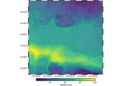
Topography of the 2018 lava flows of the Sierra Negra volcano, Ecuador.
This is a structure-from-motion point cloud of the 2018 lava flows of the Sierra Negra volcano, located on the Galápagos islands, Ecuador. The survey is of a small region on the flank of the volcano. The horizontal datum is WGS84 but the vertical datum for “elevation” is unspecified.
There are ~1,700,000 measurements in total with 3 columns available: longitude, latitude (geodetic), elevation.
Format: CSV with xz (lzma) compression.
Load with:
pandas.read_csvOriginal source: Carr, B. (2020). Sierra Negra Volcano (TIR Flight 3): Galápagos, Ecuador, October 22 2018. Distributed by OpenTopography.
Original license: CC-BY
Pre-processing: Source code for preparation of the original dataset for redistribution in Ensaio
Versions:
1 (doi:10.5281/zenodo.6139057)
- Parameters:
version (int) – The data version to fetch. See the available versions above.
- Returns:
fname (
pathlib.Path) – Path to the downloaded file on disk.
Examples using ensaio.fetch_sierra_negra_topography#
Topography of the 2018 lava flows of the Sierra Negra volcano, Ecuador