ensaio.fetch_britain_magnetic#
- ensaio.fetch_britain_magnetic(version)[source]#
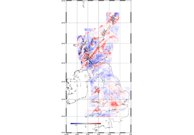
Digitized airborne magnetic survey of Britain.
This is a digitization of an airborne magnetic survey of Britain. Data are sampled where flight lines crossed contours on the archive maps. Contains only the total field magnetic anomaly, not the magnetic field intensity measurements or corrections.
The exact date of measurements is not available (only the year). The horizontal datum is WGS84 but the vertical datum is not specified.
There are 541,508 measurements in total with 6 columns available: line and segment ID, year, longitude, latitude (geodetic), height (unknown datum), total field magnetic anomaly.
Contains British Geological Survey materials © UKRI 2021.
Format: CSV with xz (lzma) compression.
Load with:
pandas.read_csvOriginal source: British Geological Survey
Original license: Open Government Licence
Pre-processing: Source code for preparation of the original dataset for redistribution in Ensaio
Versions:
1 (doi:10.5281/zenodo.5879260)
- Parameters:
version (int) – The data version to fetch. See the available versions above.
- Returns:
fname (
pathlib.Path) – Path to the downloaded file on disk.