ensaio.fetch_british_columbia_lidar#
- ensaio.fetch_british_columbia_lidar(version)[source]#
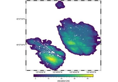
Topography (lidar point cloud) data of the Trail Islands in BC, Canada.
This is a lidar point cloud (ground reflections only) sliced to the small Trail Islands to the North of Vancouver. The islands have some nice looking topography and their isolated nature creates problems for some interpolation methods.
The horizontal datum is WGS84 and the elevation is referenced to “mean sea level”.
There are ~800,000 measurements in total with 3 columns available: longitude, latitude (geodetic), and ground elevation (orthometric).
Format: CSV with xz (lzma) compression.
Load with:
pandas.read_csvOriginal source: LidarBC
Original license: Open Government Licence - British Columbia
Pre-processing: Source code for preparation of the original dataset for redistribution in Ensaio
Versions:
1 (doi:10.5281/zenodo.5881887)
- Parameters:
version (int) – The data version to fetch. See the available versions above.
- Returns:
fname (
pathlib.Path) – Path to the downloaded file on disk.
Examples using ensaio.fetch_british_columbia_lidar#
Topography of the Trail Islands in British Columbia, Canada