ensaio.fetch_osborne_magnetic#
- ensaio.fetch_osborne_magnetic(version)[source]#
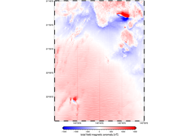
Magnetic airborne survey of the Osborne Mine and surroundings, Australia.
This is a section of a survey acquired in 1990 by the Queensland Government, Australia. The line data have approximately 80 m terrain clearance and 200 m line spacing. Total field anomalies are in nT. The flight height was calculated by summing the terrain clearance to interpolated values of SRTM (referenced to sea level). The section contains the total field magnetic anomalies associated with the Osborne Mine, Lightning Creek sill complex, and the Brumby prospect.
There are ~990,000 measurements in total with 5 columns available: flight line number, longitude, latitude (geodetic), height (orthometric), and the total field magnetic anomaly.
Format: CSV with xz (lzma) compression.
Load with:
pandas.read_csvOriginal license: CC-BY
Pre-processing: Source code for preparation of the original dataset for redistribution in Ensaio
Versions:
1 (doi:10.5281/zenodo.5882209)
- Parameters:
version (int) – The data version to fetch. See the available versions above.
- Returns:
fname (
pathlib.Path) – Path to the downloaded file on disk.
Examples using ensaio.fetch_osborne_magnetic#
Magnetic airborne survey of the Osborne Mine, Australia