ensaio.fetch_alps_gps
Contents
ensaio.fetch_alps_gps
- ensaio.fetch_alps_gps(version)[source]
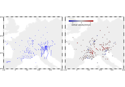
Alpine 3-component GPS velocity dataset
This is a compilation of 3D GPS velocities for the Alps. The horizontal velocities are reference to the Eurasian frame. Coordinates are referenced to WGS84. All velocity components and even the position have error estimates, which is very useful and rare to find in a lot of datasets.
There ~200 stations in total. The data available are: station ID, longitude, latitude (geodetic), height (geometric), ground velocity in the East, North, and upward directions, and the estimated uncertainties in each of these.
Format: CSV with xz (lzma) compression.
Load with:
pandas.read_csvOriginal source: Sánchez et al. (2018)
Original license: CC-BY
Versions:
1 (doi:10.5281/zenodo.5879163)
- Parameters
version (int) – The data version to fetch. See the available versions above.
- Returns
fname (
pathlib.Path) – Path to the downloaded file on disk.