ensaio.v1.fetch_earth_topography
- ensaio.v1.fetch_earth_topography()[source]
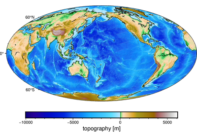
Topography of the Earth at 10 arc-minute resolution
The grid is global with node spacing of 10 arc-minutes (grid-node registered) and stored in netCDF with CF-compliant metadata.
The values are derived from a spherical harmonic model of the ETOPO1 bedrock grid. Topography/bathymetry values are referenced to “sea level” and are positive upwards.
There are 1081 x 2161 grid points in total. Coordinates are longitude and latitude (geodetic).
Format: netCDF4 with zlib compression
Load with:
xarray.load_dataarray(requires the netcdf4 library)Datum: WGS84
Original source: ETOPO1
Original license: Public domain
- Returns
fname (
pathlib.Path) – Path to the downloaded file on disk.