ensaio.v1.fetch_caribbean_bathymetry
- ensaio.v1.fetch_caribbean_bathymetry()[source]
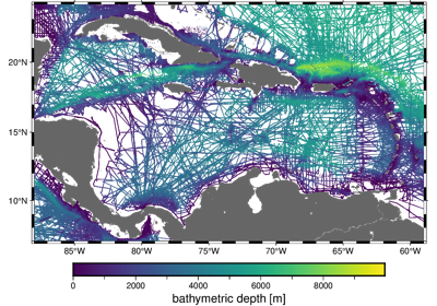
Single-beam bathymetry of the Caribbean
This dataset is a compilation of several public domain single-beam bathymetry surveys of the ocean in the Caribbean. The data display a wide range of tectonic activity, uneven distribution, and even clear systematic errors in some of the survey lines.
There are 1,938,095 measurements in total with 4 columns available: survey ID, longitude, latitude (geodetic), and depth (positive downwards and referenced to “sea level”).
Format: CSV with xz (lzma) compression.
Load with:
pandas.read_csvDatum: WGS84
Original source: NOAA NCEI
Original license: Public domain
- Returns
fname (
pathlib.Path) – Path to the downloaded file on disk.