ensaio.v1.fetch_british_columbia_lidar
- ensaio.v1.fetch_british_columbia_lidar()[source]
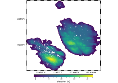
Lidar point cloud data of the Trail Islands in BC, Canada
This is a lidar point cloud (ground reflections only) sliced to the small Trail Islands to the North of Vancouver. The islands have some nice looking topography and their isolated nature creates problems for some interpolation methods.
There are 829,733 measurements in total with 3 columns available: longitude, latitude (geodetic), and ground elevation (orthometric).
Format: CSV with xz (lzma) compression.
Load with:
pandas.read_csvDatum: WGS84
Original source: LidarBC
Original license: Open Government Licence - British Columbia
- Returns
fname (
pathlib.Path) – Path to the downloaded file on disk.