ensaio.fetch_lightning_creek_magnetic#
- ensaio.fetch_lightning_creek_magnetic(version)[source]#
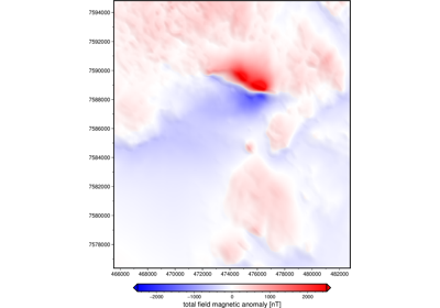
Magnetic anomaly grid of the Lightning Creek Sill Complex, Australia.
This is a section of a survey acquired in 1990 by the Queensland Government, Australia. The grid has 50 m resolution (UTM coordinates) and is at a uniform orthometric height of 500 m. Total field anomalies are in nT.
Format: netCDF4 with zlib compression
Load with:
xarray.load_dataarray(requires the netcdf4 library)Original license: CC-BY
Pre-processing: Source code for preparation of the original dataset for redistribution in Ensaio
Versions:
1 (doi:10.5281/zenodo.7079711)
- Parameters:
version (int) – The data version to fetch. See the available versions above.
- Returns:
fname (
pathlib.Path) – Path to the downloaded file on disk.
Examples using ensaio.fetch_lightning_creek_magnetic#
Magnetic anomaly grid of the Lightning Creek Sill Complex, Australia
Magnetic anomaly grid of the Lightning Creek Sill Complex, Australia