harmonica.datasets.fetch_topography_earth
-
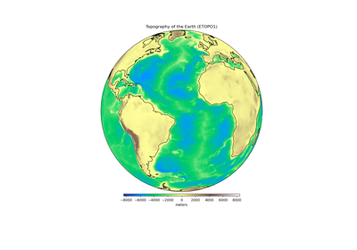
harmonica.datasets.fetch_topography_earth()[source]¶ Fetch a global grid of Earth relief (topography and bathymetry).
The grid is based on the ETOPO1 model [AmanteEakins2009]. The original model has 1 arc-minute grid spacing but here we downsampled to 0.5 degree grid spacing to save space and download times. The downsampled grid was generated from a spherical harmonic model using the ICGEM Calculation Service. See the
attrsattribute of the returnedxarray.Datasetfor information regarding the grid generation.ETOPO1 heights are referenced to “sea level”.
If the file isn’t already in your data directory, it will be downloaded automatically.
- Returns
grid (
xarray.Dataset) – The topography grid (in meters) relative to sea level. Coordinates are geodetic latitude and longitude.