harmonica.datasets.fetch_geoid_earth
-
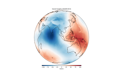
harmonica.datasets.fetch_geoid_earth()[source]¶ Fetch a global grid of the geoid height.
The geoid height is the height of the geoid above (positive) or below (negative) the ellipsoid (WGS84). The data are on a regular grid with 0.5 degree spacing, which was generated from the spherical harmonic model EIGEN-6C4 [Forste_etal2014] using the ICGEM Calculation Service. See the
attrsattribute of thexarray.Datasetfor information regarding the grid generation.If the file isn’t already in your data directory, it will be downloaded automatically.
- Returns
grid (
xarray.Dataset) – The geoid grid (in meters). Coordinates are geodetic latitude and longitude.