<xarray.DataArray 'total_field_anomaly' (northing: 370, easting: 346)>
array([[ 35. , 36.19995 , 36.69995 , ..., -101.099976 ,
-100.400024 , -99.599976 ],
[ 36.5 , 37.599976 , 38. , ..., -102.20007 ,
-101.5 , -100.70007 ],
[ 37.099976 , 38.19995 , 38.599976 , ..., -103.30005 ,
-102.599976 , -101.900024 ],
...,
[ 182.79993 , 172.40002 , 160.79993 , ..., 0.79992676,
-24.200073 , -41.80005 ],
[ 182.09998 , 172.59998 , 161.40002 , ..., 6. ,
-21.5 , -41. ],
[ 178.79993 , 170.40002 , 160.29993 , ..., 11.400024 ,
-16. , -35.80005 ]], dtype=float32)
Coordinates:
* easting (easting) float64 4.655e+05 4.656e+05 ... 4.827e+05 4.828e+05
* northing (northing) float64 7.576e+06 7.576e+06 ... 7.595e+06 7.595e+06
height (northing, easting) float64 500.0 500.0 500.0 ... 500.0 500.0
Attributes:
Conventions: CF-1.8
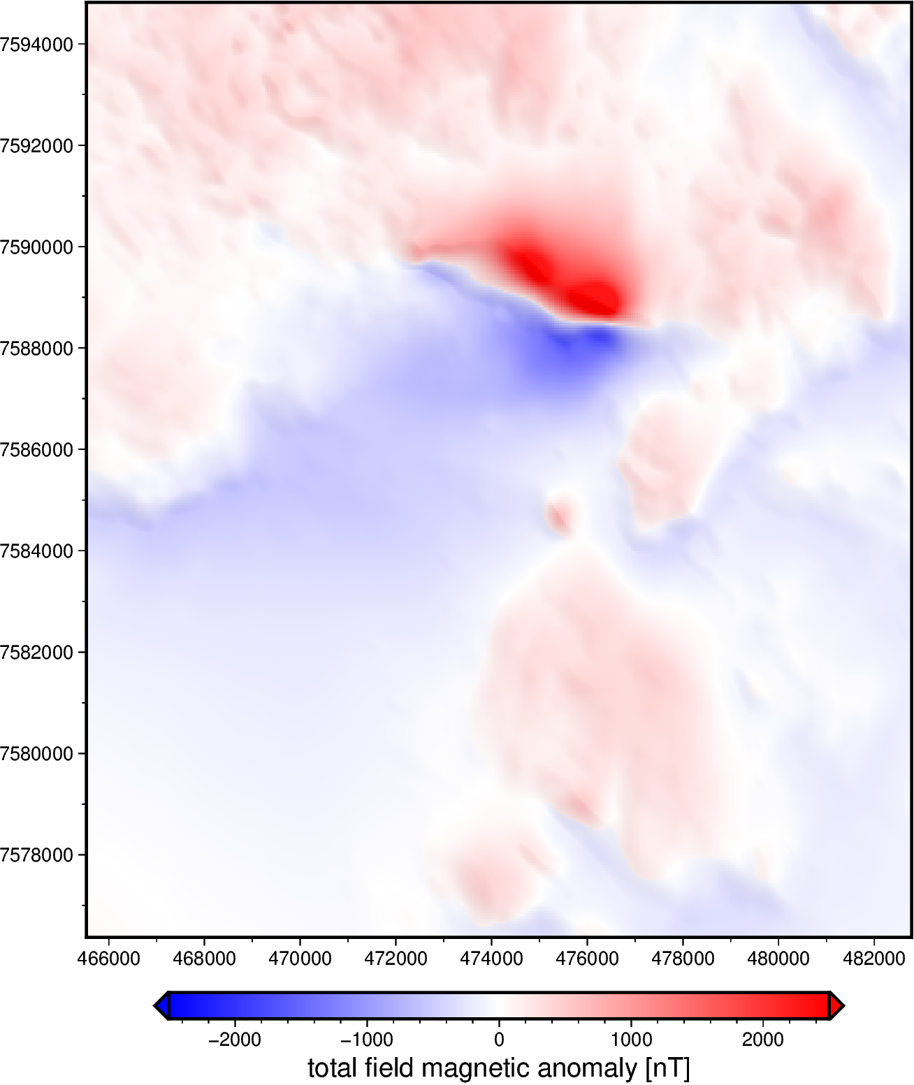
title: Magnetic total-field anomaly of the Lightning Creek sill c...
crs: proj=utm zone=54 south datum=WGS84 units=m no_defs ellps=W...
source: Interpolated from airborne magnetic line data using gradie...
license: Creative Commons Attribution 4.0 International Licence
references: Geophysical Acquisition & Processing Section 2019. MIM Dat...
long_name: total-field magnetic anomaly
units: nT
actual_range: [-1785. 3798.] 35.0 36.2 36.7 36.6 36.3 35.6 ... 113.1 78.6 43.7 11.4 -16.0 -35.8
array([[  35.        ,   36.19995   ,   36.69995   , ..., -101.099976  ,
        -100.400024  ,  -99.599976  ],
       [  36.5       ,   37.599976  ,   38.        , ..., -102.20007   ,
        -101.5       , -100.70007   ],
       [  37.099976  ,   38.19995   ,   38.599976  , ..., -103.30005   ,
        -102.599976  , -101.900024  ],
       ...,
       [ 182.79993   ,  172.40002   ,  160.79993   , ...,    0.79992676,
         -24.200073  ,  -41.80005   ],
       [ 182.09998   ,  172.59998   ,  161.40002   , ...,    6.        ,
         -21.5       ,  -41.        ],
       [ 178.79993   ,  170.40002   ,  160.29993   , ...,   11.400024  ,
         -16.        ,  -35.80005   ]], dtype=float32)
Coordinates: (3)
easting
(easting)
float64
4.655e+05 4.656e+05 ... 4.828e+05
long_name : UTM easting standard_name : projection_x_coordinate units : m actual_range : [465533.31767977 482783.31767977] array([465533.31768, 465583.31768, 465633.31768, ..., 482683.31768,
482733.31768, 482783.31768]) northing
(northing)
float64
7.576e+06 7.576e+06 ... 7.595e+06
long_name : UTM northing standard_name : projection_y_coordinate units : m actual_range : [7576368.82029097 7594818.82029097] array([7576368.820291, 7576418.820291, 7576468.820291, ..., 7594718.820291,
7594768.820291, 7594818.820291]) height
(northing, easting)
float64
500.0 500.0 500.0 ... 500.0 500.0
long_name : orthometric height standard_name : height_above_geopotential_datum units : m actual_range : [500. 500.] array([[500., 500., 500., ..., 500., 500., 500.],
[500., 500., 500., ..., 500., 500., 500.],
[500., 500., 500., ..., 500., 500., 500.],
...,
[500., 500., 500., ..., 500., 500., 500.],
[500., 500., 500., ..., 500., 500., 500.],
[500., 500., 500., ..., 500., 500., 500.]]) Indexes: (2)
PandasIndex
PandasIndex(Float64Index([465533.31767976715, 465583.31767976715, 465633.31767976715,
              465683.31767976715, 465733.31767976715, 465783.31767976715,
              465833.31767976715, 465883.31767976715, 465933.31767976715,
              465983.31767976715,
              ...
              482333.31767976715, 482383.31767976715, 482433.31767976715,
              482483.31767976715, 482533.31767976715, 482583.31767976715,
              482633.31767976715, 482683.31767976715, 482733.31767976715,
              482783.31767976715],
dtype='float64', name='easting', length=346)) PandasIndex
PandasIndex(Float64Index([7576368.82029097, 7576418.82029097, 7576468.82029097,
              7576518.82029097, 7576568.82029097, 7576618.82029097,
              7576668.82029097, 7576718.82029097, 7576768.82029097,
              7576818.82029097,
              ...
              7594368.82029097, 7594418.82029097, 7594468.82029097,
              7594518.82029097, 7594568.82029097, 7594618.82029097,
              7594668.82029097, 7594718.82029097, 7594768.82029097,
              7594818.82029097],
             dtype='float64', name='northing', length=370))
Attributes: (9)
Conventions : CF-1.8 title : Magnetic total-field anomaly of the Lightning Creek sill complex, Australia crs : proj=utm zone=54 south datum=WGS84 units=m no_defs ellps=WGS84 towgs84=0,0,0 source : Interpolated from airborne magnetic line data using gradient-boosted equivalent sources license : Creative Commons Attribution 4.0 International Licence references : Geophysical Acquisition & Processing Section 2019. MIM Data from Mt Isa Inlier, QLD (P1029), magnetic line data, AWAGS levelled. Geoscience Australia, Canberra. http://pid.geoscience.gov.au/dataset/ga/142419 long_name : total-field magnetic anomaly units : nT actual_range : [-1785. 3798.]