ensaio.fetch_southern_africa_topography
Contents
ensaio.fetch_southern_africa_topography
- ensaio.fetch_southern_africa_topography(version)[source]
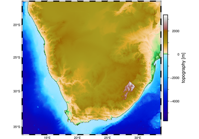
Topography and bathymetry data for Southern Africa
This is a topography and bathymetry grid with a resolution of 1 arc-minute over Southern Africa. The grid was generated by cropping the ETOPO1 global topography grid. The heights are referenced to the mean sea level.
Format: netCDF4 with zlib compression
Load with:
xarray.load_dataarray(requires the netcdf4 library)Original source: ETOPO1
Original license: Public domain
Pre-processing: Source code for preparation of the original dataset for redistribution in Ensaio
Versions:
1 (doi:10.5281/zenodo.6481379)
- Parameters
version (int) – The data version to fetch. See the available versions above.
- Returns
fname (
pathlib.Path) – Path to the downloaded file on disk.