rockhound.fetch_bedmap2
-
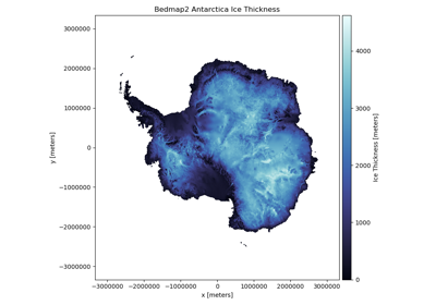
rockhound.fetch_bedmap2(datasets, *, load=True)[source]¶ Fetch the Bedmap2 datasets for Antarctica.
Bedmap2 is a suite of gridded products describing surface elevation, ice-thickness, the sea floor and subglacial bed elevation of the Antarctic south of 60°S [BEDMAP2]. The datasets are downloaded as
tifffiles and loaded into axarray.Datasetobject.Each dataset is projected in Antarctic Polar Stereographic projection, latitude of true scale -71 degrees south, datum WGS84. All heights are in metres relative to sea level as defined by the g104c geoid.
The available datasets are:
bed: bedrock heightsurface: ice surface heightthickness: ice thicknessicemask_grounded_and_shelves: mask showing the grounding line and the extent of the floating ice shelvesrockmask: mask showing rock outcropslakemask_vostok: mask showing the extent of the lake cavity of Lake Vostokgrounded_bed_uncertainty: ice bed uncertainty gridthickness_uncertainty_5km: ice thickness uncertainty gridcoverage: binary grid showing the distribution of ice thickness data used in the grid of ice thicknessgeoid: values to convert from heights relative to WGS84 datum to heights relative to EIGEN-GL04C geoid (to convert back to WGS84, add this grid)
Warning
Loading a great number of datasets may require a fair amount of memory that could crash your system. We recommend loading only the needed datasets.
Warning
Loading any dataset along with
thickness_uncertainty_5kmwould modify the shape of thegridbecause it’s defined on a different set of points.Parameters: - datasets : list or str
Names of the datasets that will be loaded from the Bedmap2 model.
- load : bool
Wether to load the data into an
xarray.Datasetor just return the path to the downloaded data tiff files. If False, will return a list with the paths to the files corresponding to datasets.
Returns: - grid :
xarray.Dataset The loaded Bedmap2 datasets.